Excavations at Aligala Prehistoric Site
- ADMIN
- Jul 24, 2021
- 18 min read

Priyantha Karunaratne and Gamini Adikari
Deraniyagala, the foremost authority on the prehistory of Sri Lanka, has done most of his excavations in the Wet Zone. By these studies he has shown data that Sri Lanka has had a long mesolithic period (Deraniyagala 1988:248). The present study is the first systematic excavation of a prehistoric site in the Dry Zone. This report presents the work carried out at Aligala during the third field season of the SARCP project. The data collated has extended our knowl edge of the prehistoric period of the Dry Zone, which up to now has been very limited. The 5th century rock fortress of Sigiriya, built by Kasyapa, has been an enigma that has con stantly drawn the interest of archaeologists and historians. The early Brahmi inscriptions in the rock shelters around the for tress show that this area had been a monastic site even in the period 2nd-3rd century BC, that is, seven or eight centuries previous to the Kasyapan era (Paranavitana 1970:67). Sc ^he F earliest date to our knowledge, of settlement in this region, was 2nd-3rd century BC until the joint excavation project carried out by the Cultural Triangle (CCF), Kommissariat fur Allgemeine und Vergleichende Archaologie (KAVA) and the Postgraduate Institute of Archaeology of the University of Kelaniya (PGIAR) at the Pidurangala caves in 1988, brought to light microliths which showed that prehistoric man had made his home in these rock shelters around Sigiriya (Johan nas unpubl.).
The decision to excavate the Aligala rock shelter for pre historic studies is one of the happy accidents of archaeology. This rock shelter was first explored in 1988 (Solangaarachchi 1990:110). The rich collection of slag finds from this first field season led to test excavations of this site in 1989, to determine whether it had been utilized as an iron production site. For this purpose two 2x2m pits were dug. The chert and quartz ge ometric microliths, anvils, bone tools, animal bones and mol lusc shells that were brought to light were clear evidence of its being a prehistoric site (Solangaarachchi and Bandara un publ.). So in the 1990 season the present excavation was set up for in-depth prehistoric studies at this site.
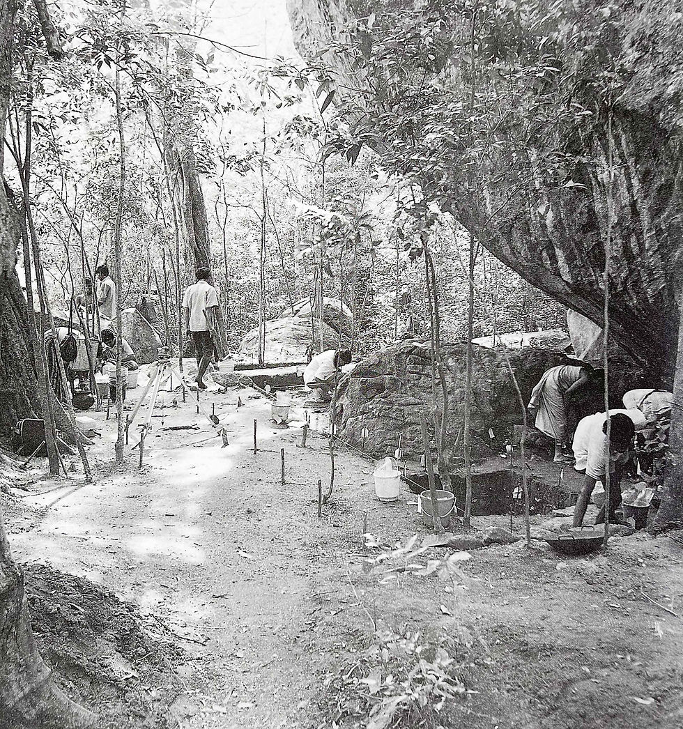
Figure 4:1 Aligala rock shelter. Excavation site from north by north-east. Photo: Mats Mogren.
Location
Aligala is situated among the rock boulders that stand tow ards the eastern side of the base of the Sigiriya inselberg. It is conical in shape and rises 15-20m above the surrounding area. In this outcrop stands a rock shelter with floor space of 4x5m. Below the rock the land is strewn with large boulders, which afford a natural barricade against predatory beasts. By this natural protection and the high location, the site lends itself as a place of security.

Figure 4:2 Map showing the location of Aligala.
Excavation
Preliminary to excavation, a grid plan was set. Two baselines were fixed, running NW-SE and NE-SW. Then grid squares lxl m were marked and serially numbered. The total extent of the excavated area, including the 1989 test pits, measures 64m (see site plan, fig. 4:5). Using the Survey Department bench mark located near the northern gate of the Sigiriya complex, a temporary bench mark of 216.51m above sea level was fixed outside the rock shelter.
Matrix account
The excavation was recorded under 27 contexts (see appen dix). Contexts 16, 24, 26, 22 and 27 all yielded prehistoric cultural data. Contexts 24 and 27 gave up remains of partly carbonated animal bones and geometric microliths, etc. This evidence gave an insight into the food, food procurement and technology and provided data to infer what the lifestyle of these humans of mesolithic times would have been. Context 1 is the top layer and context 5 has deposits of the Kasyapan or later periods. All contexts, other than the above mentioned, related to the protohistoric period and early historic period occupation (see appendix).

Figure 4:3 Aligala Rock Shelter. Site Plan
Finds
Ninty per cent of all the finds were stone implements and waste flakes. Other interesting finds were coins, beads, red ochre, graphite, potsherds, faunal remains and floral specimens. There was also a relatively small amount of tile pieces and brickbats. It is of vital importance that all the layers from the prehistoric layer onwards, except context 26, yielded artefacts (see appendix). This points to a continuous or near continuous human occupation of the site from prehistoric times onwards. The artefacts included both stone and bone implements used by the prehistoric occupants of the cave. The microliths included both geometric and ungeometric forms made of chert and quartz. The technology that was applied and the probable uses these artefacts were put to can be fairly accurately in ferred by a study of the artefacts. It is very evident that some tool (probably a larger stone) had been used to form these artefacts. Chipping on the microliths also shows signs of re touching. The bone implements too, seem to have been fashioned in the same manner. These implements were most likely used tor producing other tools (hammers) for the pro curement and preparation of food, scraping and boring, that must have met the needs of the lifestyle of their producers. Many of the geometric microliths are lunates. Their purpose has not yet been determined. It can be surmised that these lunates, since they are small in size, must have been part of a larger instrument. Scrapers of both bone and stone were found, most probably used for cleaning skin, scraping meat and fruit. They must also have been applied to scrape the bark off branches, or to skin yams. Bone and quartz pointed tools were also picked up. The bone points, used as borers were twice or three times the length of the quartz tools. The pitted hammer stones must have been a part of prehistoric man’s ‘tool box’. Of the pitted stones, the hammer is of a 6handleable’ size and weight, but there are many larger pitted stones, weighing over five kilos, which have numerous pitmarks all round their cir cumference.

Figure 4:4 Aligala. Profile of the baulk as marked in fig. 4:3.
It is the first time such pitted stones have been documented from a Dry Zone excavation. The considerable number of quartz and chert blades and leaf-shaped knives would have been used as cutting implements. Some of them show signs of having been re-touched and re-used and still have their razor sharp cutting edges.
Shells of five identifiable species of molluscs were found in the excavations (see Adikari: "Approaches" this volume). It is remarkable that all these varieties five in damp environ ments. But today typical Dry Zone climatic conditions prevail at Aligala. Only two of the mollusc species (see Adikari: "Approaches" this volume) are still to be found in the area during the wet season. This gives rise to the questions: have the climatic conditions of this region changed vastly during the intervening centuries? Why is it that only two varieties are available in this area? Were the others unable to adapt to the changing conditions? Or, were the now non-available species carried ‘home’ to the cave from the adjoining Matale area, where they abound? These molluscs must have been con sumed for food (Deraniyagala 1988:663).
A study of the osteological remains identifies 26 kinds of animals, which must have been a part of prehistoric man’s food chain (Karunaratne unpubl.). These include, large animals like the deer (axis axis ceylonensis), wild boar (sus scrofa cris- tatus), the purple-faced leaf monkey (Presbytis Sinex) and the gray langur (Presbytis entulus) which must have been formidable game for a primitively armed man to track. Small prey, like porcupine (hystix indica), the flying fox (terupus, terupus gigan tic), blacknecked hare (Lepus nigricolis Sinhala).iguana (var- anus bengalensis) had also been stalked and lolled for food Tins type of small game seems to have been more popular than the big game.
Ware, Black Ware, Red Painted Ware and Red Ware were special types of pottery excavated. Contexts nos. 1,2, 8 and 24 yielded Black-and Red-Ware, Black Ware, Red Painted Ware and Red Ware. But it was noted that no single one of their variety was exclusive to a context. Comparatively few Black- and-Red Ware sherds were collected; of them, the greater number were body sherds, with only a very few identifiable as cups and pots by the rim sherds. Pottery from Aligala context 8 and the surface of context 24 is very similar to the pottery finds 191 3, 19L and 5M 2, from the Anuradhapura Gedige excavations (Deraniyagala 1972:70,78). The technology used to produce these wares is neither crude and primitive, nor highly polished. They are fairly hardy pieces, made of sand grit about l-2mm in size. Context 24 is definitely a prehistoric layer. So we can be almost sure that pottery sherds are totally out of place here. These sherds must have come down from the upper contexts. These have been made of a fine sand-clay-mixture, but do not show a good finish. Only contexts 1 and 2 yielded Painted Ware. These were very few in number and all were painted on both sides and disclosed technology of a very high order. Plain Red Ware was common in all the layers that yielded pottery, but those sherds do not show a high level of technology. A mixture of quartz grit averaging 2mm, sand and clay had been used. The pottery finds from the excavations were identified as sherds of cups, trays, bowls, cooking pots (atilt), large water pots, small water pots (kotala), storage vessels and lids. Dec orated body sherds were found from contexts 1, 2, 4 and 6. The decorations had been incised in the clay, prior to firing. Not a single sherd showed graffiti marks. A type-and-ware analysis of the sherds showed that the greater number belonged to artefacts of the proto and Early Historic period. A few sherds from the uppermost layers had a close similarity to the types identified as of the Kasyapan era, which were found from the western sector excavations of the Sigiriya complex.
14 C – dating
From the presence of Black-and-Red Ware pottery on the surface of the prehistoric layer (context no. 24) it was as sumed that the last date for mesolithic settlement would be around the 1st or 2nd millenium BC. This idea was further confirmed by the 14C-dating for two samples from context 24, which gave calibrated age ranges from cumulative probability (using one sigma) at 3516-3270 BC (Ua 5503) from the lower level of the context, and 2362- 2119 BC (Ua 5504) from the upper level of the context. There is a difference of approximately 1000 years. Although these are very recent dates lor a mesolithic site, when compared with Batadombalena, Belilena and other Wet Zone sites so far dated, they are in line with the established view of Lankan prehistory that mesolithic man occupied this region in the 3rd and 2nd millenium BC. The protohistoric layer, context 8, which had Black-and- Red Ware pottery, is dated 998-848 BC (Ua 5502). Consider ing the megalithic tradition in protohistoric settlements dated in India, this is a reasonable date for this type of habitation. But it must be noted that for Sri Lanka, it is one of the earliest dates so far for a megalithic culture. As a source-critical remark it must be stated that the age of the wood before burning is unknown and that not too much reliability can be attatched to a single sample. The result can stand as a point of departure for further discussion and research.

Figure 4:5 Aligala. Radiocarbon dates. Calibrated age ranges from cumulative probability, one sigma (68.26%). Calib ETH 1.5b (1991).
Conclusions
Several phases of habitation were revealed through the 27 contexts at the site (see appendix). On reading the strata from the earliest to the topmost level, two prehistoric settlement phases, a protohistoric phase and an Early Historic habitation can be identified, but it is a matter of great archaeological interest that, although Aligala stands well within the Sigiriya Citadel and these phases of settlement can be traced, there were only a few sherds that belonged to the historical Kas yapan era (contexts 1, 2 and 5, see appendix). It is further intriguing that these contexts belonged to the Early Historic period. So it is possible that they had filtered in as a result of activities during the Kasyapan era, or washed down from the rock. Context 27 is the earliest prehistoric layer and context 24 is the second prehistoric phase. Between these is a phase (context 26) which must have been a period of abandonment. The few cultural remains found would have belonged to con text 27 and have moved to the upper layer, and some from context 24 may have settled on the top of context 26. This is the only possible interpretation of their presence in context 26. An analysis of the microliths from context 24 and 27 shows that they belonged to prehistoric mesolithic men who occupied this site, abandoned it for some reason, and re-oc cupied it again. A view of the lifestyle of these earliest settlers came into sight through the geometric microliths, bone tools and anvils they created, the faunal and floral remains of their ‘tables\ the red ochre they used to gratify their vanity, or as part of their ritualistic ceremonials, probably to find protection from the predatory animals and the inexplicable phenomena of nature; and fertility for the herds of game they hunted.

Figure 4:6 Aligala. Context matrix.
REFERENCES
Deraniyagala, S.U. 1972. The Citadel of Anuradhapura 1969: Excavations in the Gedige Area. Ancient Ceylon. 2:48- 164.
Deraniyagala, S.U. 1988. The Pre-history of Sri Lanka: An Ecological Perspective. Ph. D. dissertation Department of Anthropology, Harvard University, Cambridge, Mass.
Johannas, M. The Lithic Assemblage from Pidurangala. Un published Survey Report. PGIAR Archive. Cat. No 93/6.
Karunaratne, P.B. Report on an Ecological Survey of Forests and Identification of Faunal Remains from Archaeologi cal Sites Around Sigiriya. Unpublished Preliminary Sur vey Report. PGIAR Archive. Cat. No.89/26.
Paranavitana, S. 1970. Inscriptions of Ceylon 1. Colombo. Department of Archaeology. Solangaarachchi, R and T. Bandara. Aligala site. Unpub lished Preliminary Excavation Report. PGIAR Archives. Cat. No. 1989/1-10.
Solangaarachchi, R. 1990. Preliminary Explorations in the Eastern Precinct. The Settlement Archaeology of the Sig- iriya-Dambulla Region. Bandaranayake S., M. Mogren and S. Epitawatte (eds.). Colombo: PGIAR.
Appendix:The Matrix Description
Context No. 1
This is a humus layer. It is approximately 10cm thick and lies over the whole excavation site. Prehistoric implements such as chert and quartz, and historical remains such as iron slags and potsherds, have been found in this layer. This has oc curred as a result of attack by termites and the material that was deposited in the highland being washed downhill and re-deposited. The ground slopes towards the north.
Context No. 2
This layer is deposited above context 24 and below context 1 and extends beyond the cave. Potsherds and iron slags are extensively found in this layer. Mollusca shells, chert, quartz flakes, tools, bone remains and small iron flakes were found in abundance as notable cultural finds. Black-and-Red Ware and Red Ware potsherds were also found in this layer. Towards the wall of the cave this layer has been extensively attacked by termites. As a result this layer is somewhat disturbed. Never theless the finding of Black-and-Red Ware from the layer directly opposite the prehistoric layer (context 24) is impor tant.
Context No. 3
This is deposited below contexts 8 and 23 and above con text 24 and 25. Here the layer is an admixture of small pieces of iron slag, potsherds (Black-and-Red Ware, Red Ware) mol lusca shells, quartz, chert and remains of bones. It seems that the pit which was called context 6 had been dug and heaped up, thus being subjected to re-deposition as context 3. Texture: Sand 20 % ; Clay 60 % ; Silt 20%. The layer slopes towards the west, south and east.
Context No. 4
This context is deposited below context 5 and 2 and above context 9 and 14. It slopes towards the north. Fragments of brick and potsherds were found. It appears to have been dep osited by flowing water. The context is limited to the northern section, outside the cave. It has very high compaction. Tex ture: Sand 40 %; Clay 50 %; Silt 10%.
Context No. 5
This is deposited below context 1 and above context 2. The layer extends only towards the northern sector of the excava tion site. Within the cave, context 5 has not been deposited. Cultural remains are few in number and the ground slopes towards the north. It appears to have been formed by material brought by flowing water. Texture: Clay 40 % ; Sand 40 % ; Silt 20 %. Context No. 6 This is deposited below context 1 and above context 24.
Context 6
had been located in a pit dug prior to the deposition of context 2. In this layer the percentage of potsherds and iron slags was higher than that of the earth. Therefore it seems that this pit had been filled with potsherds and iron slags. Half of this pit, which belongs to context 6, had been excavated in the 1989 field season which extended into the squares (11/44), (11/49). Texture: Sand 60 % ; Mud 30 % ; Silt 10 %.
Context No. 7
This is deposited below context 1 and above context 12. This layer appears to be contemporaneous with context 2. The reason that led to its being assigned a context number is the formation of a layer with the thickness of about 10cm, with deposits of small iron slags. This extends between square (11/50) and (10/50). Potsherds were found at random. This layer slopes towards the north.
Context No. 8
This is deposited above contexts 15 and 3 and below con texts 2,12 and 10. The distribution of the layer extends beyond the limit of the cave. At the same time it is limited to the southern quarter of the excavation site. A considerable amount of fragments of burnt clay and potsherds was recovered from this layer. Black-and-Red Ware pot sherds were also recovered. It is clearly seen that this is an undisturbed layer, belonging to the Early Historic or Protohistoric period. The recovery of fragments of burnt clay, at random, is a special feature of this layer. It is possible that these may be the remains of some disintegrated construction (hearth or kiln).
Context No. 9
This is deposited below context 8 and overlying context 16. Potsherds and stone tools were recovered from this layer. It slopes towards the north and is deposited by the flow of run ning water. Texture: Sand 50 % ; Clay 40 % ; Silt 10 %.
Context No. 10
This is deposited below context 4 and above context 9. It slopes towards the north. A few potsherds and quartz flakes were found. This may be an artificial layer formed with earth filled at a later date. Texture: Clay 50 % ; Sand 40 %, Silt 10 %.
Context No. 11
This is deposited below context 4 and above context 17. It slopes towards the north. In a small area of the excavation site some evidence of cultural activites was available. A few pot sherds and a few quartz flakes have been recovered from this layer. This is a layer formed of earth deposited by running water. Texture: Clay 50 % ; Sand 40 % ; Silt 10 %.
Context No. 12
This is deposited below context 7 and above context 8. This is a layer prominently mixed with sand and contains very little cultural residue. The percentage of sand is very high. It appears to have been deposited with sand and swept away by running water. It must be noted that this layer slopes towards the west.
Context No. 13
This is deposited below context 4 and above context 19. When its composition and cultural importance is taken into account, it is similar to context 8. But context 13 occurs only in an area of about 3xlm to the north of the excavation site, close to the wall of the cave. This layer slopes towards the north. Potsherds, fragments of burnt clay and quartz flakes are found. This has been deposited by the flow of running water.
Context No. 14
This is deposited below context 4 and above context 19. This is a layer with high compaction. It has little evidence of cultural activities. A part of a small (Black-and-Red Ware) clay vessel was discovered. The distribution of this layer com mences at the point where the northern wall and the eastern wall connect, at the corner of the excavation site. It slopes towards the south. This is formed of earth carried by flowing water. Texture: Clay 30 % ; Sand 50 % ; Silt 20 %.
Context No. 15
This is deposited above context 18 and below context 8. In composition, colour and compaction, it is similar to context 8. Minute iron slags, excessively decayed potsherds, red spots that could be the debris of burnt clay, were scattered all over the layer. A noteworthy factor regarding this layer is the pre sence of ‘Black-and-Red Ware’ potsherds in large numbers. Texture: Clay 60 % ; Sand 30 % ; Silt 10 %.
Context No. 16
This is deposited below contexts 17 and 9 and above con text 19. This layer is spread in a small area outside the cave It is a prehistoric layer. Hie notable difference in this layer is that there were no faunal remains, as in the other prehistoric layers. Chips of quartz and core samples are found here. Stone tools had been produced at this location during of deposition of this context. Texture: Sand 50 % ; Clay 40 % ; Silt 10 %.
Context No. 17
This is deposited below context 11 and above context 10. The evidence of cultural activities is scarce. However, several quartz flakes and a few tools were in evidence. This layer does not extend as far as the back limit of the excavation; it does not show in the profile. It slopes gently towards the north and it has less compaction than context 11. It is a natural deposit. Texture: Clay 40 % ; Sand 40 % ; Silt 20 %.
Context No. 18
This is deposited below context 15 and above context 21. As regards the composition, it is similar to context 8 and 15. The cultural evidence found here is similar to that in context 15. Badly eroded unidentifiable potsherds were also found. Red spots, which appear to be burnt clay objects which have disintegrated, were seen all over the layer. Apart from this, quartz and chert and stone tools were found in this layer. Texture: Sand 50 % ; Clay 40 % ; Silt 10 %.
Context No. 19
This is located above context 20 and below the contexts 14, 16, 17, 27 and 21. Context 19 consists of a layer of weathered granite which lies over context 20. This layer of sherds of granite has fallen from the front of the rock shelter and disin tegrated after decay. Prehistoric human settlements had sprung up on this layer of granite. Even after the removal of context 27, inside the cave as well as around it, a large number ol these sherds were still scattered. Sherds of diverse sizes, used as implements and splinters and cast away as waste, were found in abundance. •
Context No. 20
A reddish brown gravel layer. The depth after excavation was not sufficient to ascertain the thickness of the layer. Nev ertheless the depth of the gravel layer in the experimental pit, excavated in 1989, was about 80cm. At the moment the ex cavations have been suspended. This is a layer without any sign of human settlement. This layer appears to be virgin soil. It stops towards the north. Texture: Gravel 50 %, Sand 20 % and Clay 30%.
Context No. 21
This is a fairly large layer made up of big grains of sand with hard earth. Il is located below context 25 and overlaying
context 24. This has been deposited by water. Prehistoric im plements such as pitted hammer stones, red ochre, quartz flakes and micro tools were found in this layer. However, in comparison with the prehistoric contexts 24 and 27, archa eological finds such as snail shells and other remains are not found in this layer, which has been deposited by water and slopes towards the south. Texture: Sand 50 % ; Clay 40 % ; Silt 10 % .
Context No. 22
This context is part of context 27. See description below.
Context No. 23
This is deposited above contexts 24,3 and below context 1. According to the colour, it is similar to the layer belonging to the prehistoric period. But in composition and compaction it differs from the prehistoric layer. There were potsherds and fragments of brick to be found here, as well as mollusca shell remains which were also mixed in it. A piece of a flat glass bead and a few stones were also found in this layer. The layer is about 30cm thick, slopes towards the north and is formed by the flow of running water and human activity.
Context No. 24
This context is located below contexts 3, 2, 8, 21,18,15, 6 and 25 and above contexts 26 and 27. This context stands within the cave and can be described as a low mound, highest at the centre and sloping gradually outwards to the circum ference. Compared to the other layers, this displays exclusive micro-physical features. To interpret the reason why context 24 slopes from the interior to the exterior of the cave is compli cated. Very often sloping of this type is likely to occur as a result of water flowing through the roof of the cave, and in the process leaving deposits of gradual erosion. If this were not the reason, it may have been due to the activities of prehistoric man. This layer possesses features not found in other layers. It contains hundreds of mollusc remains, which is a notable fea ture. Apart from these, the faunal remains of animals, from small to such as wild boar (sus scrofa cristatus) which had been hunted by prehistoric humans, were found in abundance in this layer. Sharpened bone tools and tools made of quartz and chert, which take various shapes, along with those in geometrical designs, were found in this layer. And also L pitted hammer stones’ and red ochre used for colouring, were found here. Notable too, is the presence of Black-and-Red Ware potsherds lying on the surface. This could be an Early Iron age culture that settled in this cave immediately after prehistoric men abandoned it. Texture: Clay 60 % ; Sand 20 % ; Silt 10 % .
Context No. 25
This is deposited above context 24 and below contexts 1,2, and 3. The layer slopes towards the south. According to the manner of sloping, it seems to have drifted with the flow of water, resulting in deposition. Pieces of decorated terracotta were found scattered all over the layer. These have been col lected as samples. This layer has yielded a few terracotta beads, stuck together. They are similar to beads recovered from excavations carried out at the citadel in Anuradhapura. Similar beads had been recovered from the megalithic burials of Ibbankatuva. Texture: Clay 60 % ; Sand 30 % ; Silt 10%
Context No. 26
This is a thin deposit located under context 24 and above context 27. This layer slopes from the middle of the cave towards the front (the east) and extends forward. Here, cultural remains are rare. Apart from a few lithic debris, no other cultural remains were found. These splinters may have em erged from context 27, or those which had fallen from context 24 This layer, which lies between context 27 and 24, reveals that the cave had been abandoned for some time (it is devoid of human habitation). This layer has been deposited by water, wind or dust. Texture: Sand 65 % ; Clay 25 %; Silt 10 % .
Context No. 27
This is located under the contexts 26 and 24 and above context 19. This layer has been deposited as a result of prehis toric human activities. This layer is harder than context 24, but in respect of cultural remains, it is similar. From this layer a number of ‘pitted hammer stones’ were recovered. Apart from these, and for the first time in the Dry Zone, two anvils were recovered from this layer. Tools made of bone remains, chert and quartz were found in large numbers. While the layer slopes towards east, west and south, the highest layer reached lies in the centre of the cave. Texture: Clay 40 % ; Gravel 20 % ; Sand 20 % ; Silt 20 % .


Comments